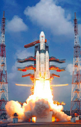
NEW DELHI (TIP): After the historic lift-off of India‘s heaviest rocket GSLV-Mk III, Indian Space Research Organisation (Isro) is gearing up to launch a C a r t o s a t – s e r i e s satellite, also called the ‘eye in the sky’ because of its surveillance capabilities, into the 505-km polar sun synchronous orbit by the end of this month.
The 550kg satellite, the fourth of the Cartosat-2 series, is to be launched by the PSLV-C38 rocket. The Cartosat-series satellite is an advanced remote sensing satellite capable of providing scene-specific spot imagery. It carries a state-of-the- art panchromatic (PAN) camera that takes black and white pictures of the earth in the visible region of the electromagnetic spectrum. The swath covered by this high resolution PAN camera is 9.6 km and their spatial resolution is less than 1 metre. The satellite, which can be steered up to 45 degrees along as well as across the track, covers the entire globe in 1867 orbits on a 126-day cycle.
The Cartosat-2C series satellite has added teeth to India’s military surveillance and reconnaissance capabilities, and has been providing high-resolution images of 0.65 metres, an improvement over the 0.8m resolution of the earlier missions.
The first major use of the Cartosat-2C satellite by the military was when the Army commandos counted on satellite images to hit terror launch pads across LoC during the surgical strike in September.
The imagery of Cartosat satellite is significantly used for cartographic applications, urban and rural applications, coastal land use and regulation, utility management like road network monitoring, water distribution, creation of land use maps, precision study, change detection to bring out geographical and manmade features and various other land information system (LIS) and geographical information system (GIS) applications.


Be the first to comment