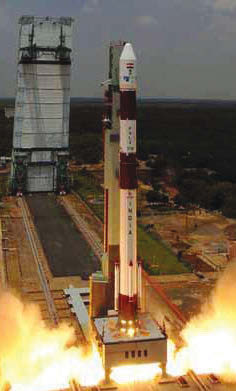
CHENNAI (TIP): Isro scientists on Thursday successfully launched the sixth in the constellation of indigenous regional navigation satellites that would help India establish its own GPS-like system.
After lifting off at 4 pm on March 10 from the second launch pad at Satish Dhawan Space Centre on the Bay of Bengal island of Sriharikota, 90 km north of Chennai, Isro’s most trusted Polar Satellite Launch Vehicle –PSLV-C32-successfully placed the IRNSS-1F in the intended orbit.
Following that, the satellite’s solar panels were automatically deployed and ISRO’s Master Control Facility at Hassan in Karnataka took charge of its operations.
“PSLV-C32 carried IRNSS-1F to the right orbit,” Isro chairman A S Kiran Kumar said, adding that the seventh and final satellite in the system, IRNSS-1G, would be launched next month. Like others, IRNSS- 1F is designed to provide accurate position information service to users in India and in the region extending up to 1,500 km from its boundary.
With the lifespan of 12 years, IRNSS-1F carried the navigation and ranging types of payloads. Its lift-off wait was 1425 kilograms.
The navigation payload of IRNSS-1F will transmit navigation service signals to users, operating in L5-band and S-band. While providing Standard Provisioning Service, the satellite will also perform navigation parameter generation and transmission, satellite control, ranging and integrity monitoring, besides timekeeping.
The PSLV rocket has put IRNSS-1F into a sub geosynchronous transfer orbit with 284 km perigee (nearest point to earth) and 20,657 km apogee (farthest point to earth) with respect to the equatorial plane.
